200,000 Steps on the Lone Star Hiking Trail
This 96-mile journey from Richards to Cleveland offers respite from the pandemic and urban sprawl.
A version of this story ran in the May / June 2023 issue.
I grew up in northwest Austin at the edge of the Texas Hill Country, where hiking through the woods and playing in creeks were daily activities. So, I’ve always been an “outdoors person.” After moving to Houston for a journalism job, I quickly began running and biking along the city’s mostly concrete-lined bayous. Then an environmental activist told me something intriguing: Just an hour north of the traffic and skyscrapers of downtown Houston is the 96-mile Lone Star Hiking Trail, the longest footpath in Texas.
During April 2020, I began a quest to hike the full trail along with a friend in my “COVID bubble.” It was a sunny and unseasonably hot day as we embarked from mile marker zero inside the 163,000-acre Sam Houston National Forest. So early in the pandemic, we hiked without seeing another person, hearing a car on the road, or spotting an airplane in the sky. The only sounds were chirping birds, squirrels and lizards scurrying, and the wind blowing through the leaves.
It was a Coronavirus-safe activity and I was hooked.
On maps, the national forest is depicted as a massive patch of public land. But on the ground, hundreds of U.S. Forest Service tracts are broken up by private timberlands, farms and ranches, and a growing number of rural homes and subdivisions. Mostly flat to rolling terrain, the forest is laced with creeks as well as the east and west forks of the San Jacinto River and the not-so-scenic lanes of Interstate 45.
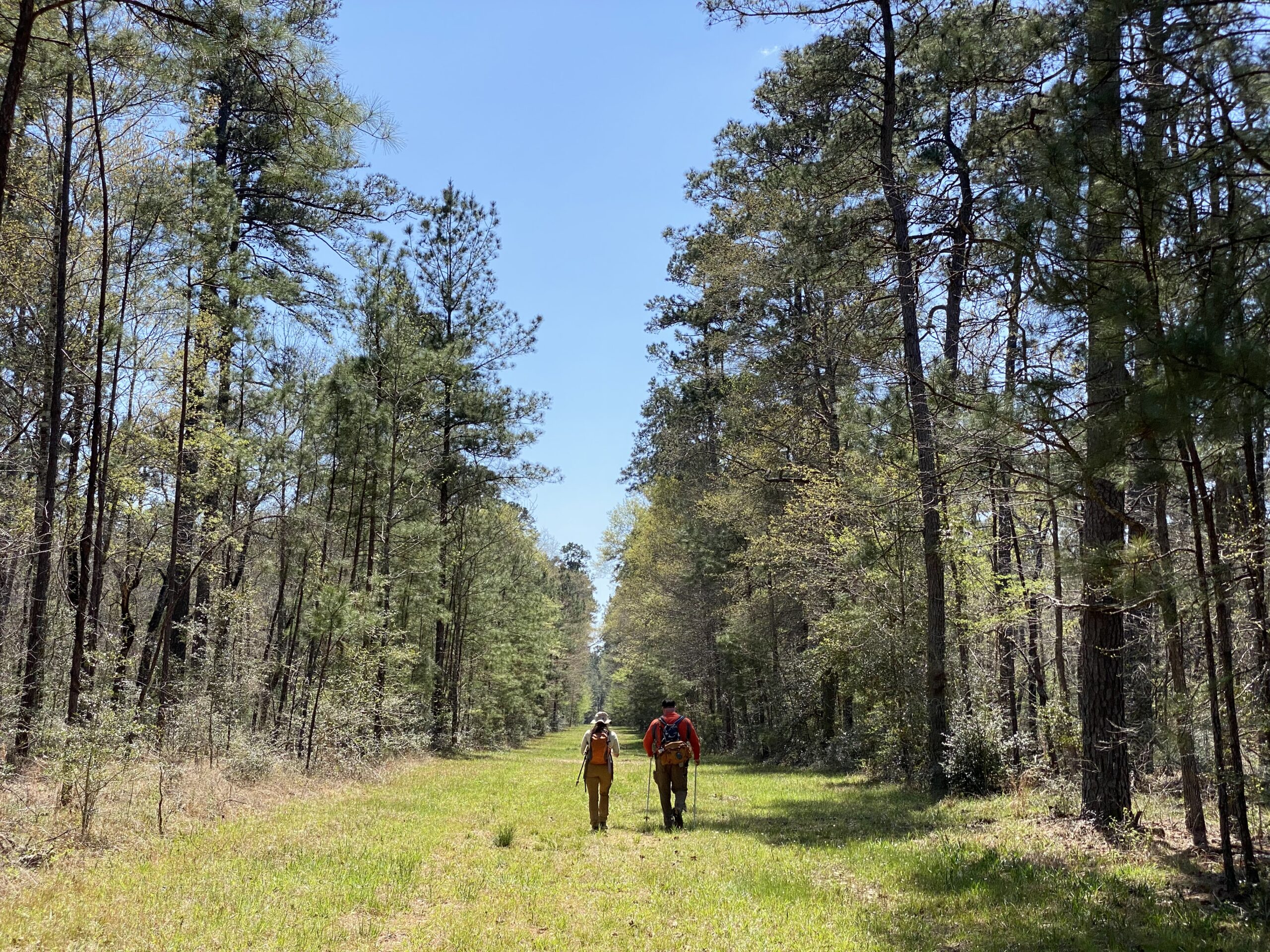
Starting near Richards and ending near Cleveland, the Lone Star Hiking Trail proper is 96 miles through the forest with five optional loops adding another 32 miles. Depending on one’s height and weight, that’s roughly 200,000 steps. Given a pace of about three miles per hour, it would take roughly 32 hours to hike the entire trail nonstop. Hiking about eight hours per day means less than a week of hiking and camping.
But that’s not the path I chose.
It took me sixteen trips with various friends over two years to hike the entire trail. Confession: We weren’t disciplined about it; sometimes weeks or months lapsed between forays. Most often, I’d park my car at one of the 15 trailheads and we’d hike for five or six miles and then head back. On every visit, the trail provided valuable relief with its clean air, social distancing, and an escape from the four-wall confinement of lockdown and stress. Our slower approach allowed us to experience the forest in all four seasons.
Our slower approach allowed us to experience the forest in all four seasons.
Spring is marked by fresh light green leaves, wildflowers and white color pops of dogwood and magnolia blossoms. The summer can be brutally hot, but it’s the best time to enjoy Lake Conroe or Double Lake. The fall brings orange, red, and yellow hues as purple beautyberries and red yaupon holly berries ripen in the understory. Pine trees and oaks stay green during winter while colonies of colorful mushrooms and fungus sprout on the forest floor.
I shared our hikes on Twitter and Instagram, and the Lone Star Hiking Trail became a hit with my social media followers too.
It’s much easier to hike the trail virtually. To do it in person, you need plenty of water, snacks, insect repellent, spare socks, powder, paper towels and wipes, and willingness to rough it, since there are no bathrooms or vending machines aside from spartan amenities at the Stubblefield and Double Lake campgrounds. Good walking shoes and long pants with high socks reduce risks of scratches, bug bites and ticks. Snakes on this trail mostly flee from people. However, mosquitoes and spiders are fearless.
Early morning hikes meant the person in the lead breaks overnight cobwebs. Scat with fur signaled coyotes and bobcats, but the most worrisome signs were the wallows and rooting of feral pigs. My worst fear was encountering hogs, which can attack when frightened or startled. Luckily, we never saw any.
Sam Houston is one of the state’s four national forests created by Congress during the Great Depression. The timber industry previously clear-cut large swaths of the Piney Woods. State lawmakers bought hundreds of barren tracts in 1933, with the intent of adding them to the national forest system. President Franklin D. Roosevelt proclaimed Angelina, Davy Crockett, Sabine, and Sam Houston national forests in October 1936. Roosevelt’s Civilian Conservation Corps planted millions of trees. The U.S. Forest Service gave the Lone Star Chapter of the Sierra Club permission to build the trail in 1967. The trail and all its loops were complete by 1978.
It’s big enough that you can easily get lost. I’m an experienced outdoorsman, but we’ve gotten lost on the Lone Star Hiking Trail, marked by small reflective markers nailed into the trunks of trees. It’s easy to lose track of the markers after leaving U.S. Forest Service land and walking down a rural road to the next section. Cell-phone service can be spotty, so it’s best to download Lone Star Hiking Trail Club maps in advance.

But not all of this wilderness is protected. Legally distinct from national parks and refuges, national forests can be used for hunting, fishing, timber, grazing, mining, oil, and natural gas. By law, the U.S. Forest Service must manage Sam Houston with no single resource emphasized over others. To that point, the 163,000 acres also include trails for ATVs, mountain bikes, and horses. Lakes are stocked with bluegill, largemouth bass, and catfish. Oil wells and easements for pipelines and power lines are common.
Historically, wildfires kept the forest from getting too dense and unhealthy. Today, the U.S. Forest Service uses controlled burns and sustainable timber harvesting in efforts to control a pest known as the southern pine beetle and improve habitat for the red-cockaded woodpecker, an endangered species that favors open “pine savannas” and nests from April to June. Over the decades, environmentalists and forest managers have sparred in court over forestry practices related to the beetle and woodpecker.
I looked for those woodpeckers, but only heard their distinctive high-pitched chirps and tap tap-tapping hidden in the canopy.
Sprawl and suburbanization are the biggest threat to the forest and to this trail.
Sprawl and suburbanization are the biggest threat to the forest and to this trail. I-45, the busy thoroughfare connecting Houston and Dallas, divides it in two, creating a formidable barrier for wildlife and people. The Texas Department of Transportation spent millions improving a 15-mile stretch of highway between Huntsville and New Waverly but spent little on allowing hikers or wildlife to cross safely under the roadway where cars speed past a white 67-foot statue of Texas founding father Sam Houston.
I wish the Texas legislature would use some of its $32.7 billion budget surplus to create a buffer for this trail—and improve the crossings that either don’t exist or have been damaged and make a through-hike so challenging. Unfortunately, this year has seen news in the opposite direction: The state recently lost a lovely park further north on the I-45 corridor that offered its own woodland paths.
In theory, animals can use the narrow corridor where Big Chinquapin Creek goes under the highway, but hikers must trudge four miles along three rural roadways and the I-45 frontage road in order to reach the next trail section.
Country-club communities such as Elkins Lake and the Texas Grand Ranch subdivision with its two- to five-acre lots allow people to live at the edge of the forest. As an unintended result, nonnative ornamental plants are escaping into the wild and becoming invasive species. The average person may not notice, but I kept spotting exotic plants like nandina, wax-leaf ligustrum, Chinese tallow, chinaberry, bamboo, and hardy orange all along the trail.
Volunteers with the Lone Star Hiking Club and the Houston area Sierra Club maintain the trail and try to clear out invaders. I’d love to give back and join them one day.
But it’s a big job—and progress is often slow.
A vehicle bridge to the Stubblefield Campground washed out during Hurricane Harvey in August 2017 but was not rebuilt until 2022. A footbridge over scenic and shaded bluffs of the east fork of the San Jacinto River in the Magnolia section of the trail was destroyed more than eight years ago and never replaced.
Hikers are forced to take a complex detour, though I opted to park my car at the next trailhead and walk to the opposite bank.
Even as the pandemic fades, I’m still going back for more, particularly to hike the loops outside the main trail. To me, this escape seems even more valuable with Houston growing at a pace that will see it overtake Chicago as the third-largest U.S. city. Even as the metropolitan area expands in all directions, the forest still offers respite.
You May Also Like

In Congress, Christian Menefee Says He’s Fighting for ‘the Least, the Last, and the Lost’
The latest politician to represent H-Town’s historic 18th Congressional District talks about his recent primary against Al Green, ICE, voting rights, and the U.S. Senate race.

A Birth Plan for the Dying
When an ultrasound reveals a lethal fetal anomaly, each image is the unwinding of a miracle. Then, Texas' abortion ban makes the nightmare even worse.

Christian Menefee’s Win Foreshadows Fights to Come Across the South
Al Green was a fighter past his prime, and Houstonians finally chose a new direction. But a post-Voting Rights Act world means that intraparty fights over Black representation are just beginning.