by Zoë Schlanger
August 20, 2018
–
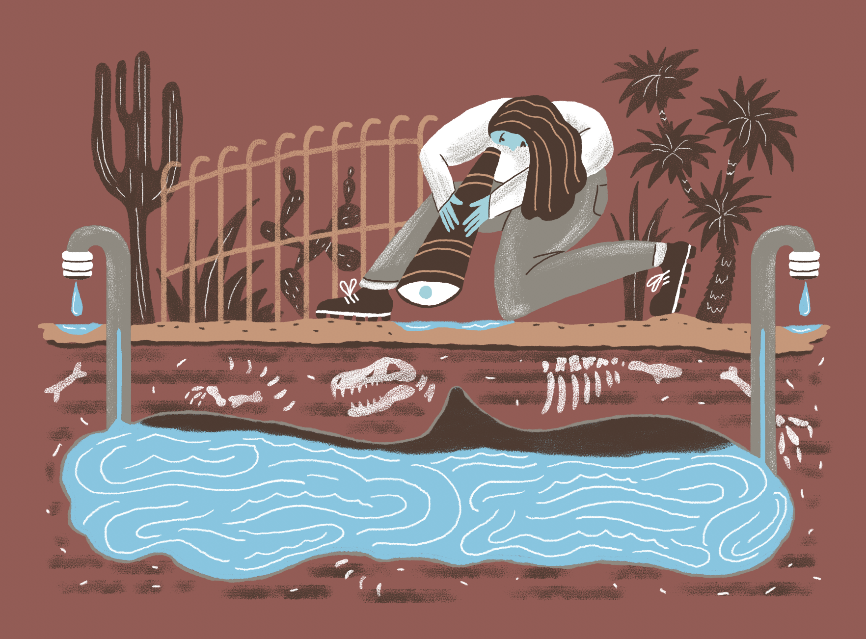
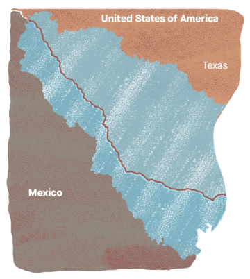
All along the 1,250 miles of border between Texas and Mexico, hidden under hundreds of feet of soil and rock, lie more than a dozen underground aquifers—areas of permeable earth that hold water—that crisscross the national boundaries. They might be the only sources of water the region will have left when the Rio Grande, hit by a one-two punch of climate change and a booming population, inevitably dries up. And yet there is no binational agreement for all this shared groundwater.
Texas and Mexico have elaborate sharing agreements for every acre-foot of water that flows through the Rio Grande, which makes sense, especially since the river is dwindling. Making sure both sides are upholding those agreements while the region rides through its regular whiplash of droughts and floods takes up most of the bandwidth of water officials on both sides.
Meanwhile, the US and Mexico barely even know about their shared groundwater. The two nations only officially recognize four cross-border aquifers (pdf). But Rosario Sanchez, a Texas A&M University hydrologist who has spent her academic life seeking out transboundary aquifers that aren’t yet on maps, has identified 36. Of those, 15 are shared between Texas and Mexico.
This is how it goes with humans and the invisible forces that enable—or disable—our lives. We don’t notice them until something goes wrong. This is how it goes for groundwater. We stick our straw in and drink up until it runs out, or the land sinks beneath our feet, and we can no longer pretend the source of our water is magically unlimited and reliable.

It’s a crisis that has, by now, been unfolding in the background for a while. “[C]ompared to the issues of illegal immigration, drug violence, economic trade, and other border and non-border issues, groundwater management ranks relatively low among the priorities of both federal governments,” wrote Gabriel Eckstein, a water-law scholar at Texas A&M School of Law, in a 2012 paper (pdf). “As a result, the [Rio Grande Valley region’s] groundwater resources are being overexploited on both frontiers as populations and industries pump with little regard for sustainability or transboundary consequences…. Ultimately, the viability of the region’s communities, natural environment, and economic growth are threatened with stagnation and may falter. And no one, at least on the federal level, is doing anything about it.”
Groundwater depletion will threaten communities on both sides before long, says Sanchez. Temperatures in the Rio Grande Valley are rising, and droughts are expected to become (pdf) more frequent. Surface water—the water from streams, lakes, and other above-ground sources—in the region is vanishing. In 15 or 20 years, Sanchez says, the Rio Grande will be a pitiful stream. Meanwhile, the population in the Rio Grande Valley is projected to more than double by 2060 (pdf). All those new border residents will need a lot more water, just when the river starts truly struggling to meet demand. That will likely spark a run on groundwater. Sanchez predicts the neglected resource will become a major geopolitical issue in the region.
Sanchez is from Saltillo, the capital of Coahuila, an enormous Mexican border state that kisses the Texas frontier from Big Bend in West Texas down to Laredo, more than 300 miles to the southeast. She moved to the US in 2000 while working for the Mexican foreign service, and to Texas in 2006, to begin her PhD at Texas A&M. At 41, she’s spent almost half her life in the US. She understands this is an issue for both sides. “Very few people have been able to acknowledge how risky it is not to know what is going on with groundwater on the border,” she says. “Nobody actually pays attention to it.”
As far back as 1973, the International Boundary and Water Commission, a joint US-Mexico body that governs border water, added a clause to their water-sharing agreement that acknowledged a need for groundwater rules that both countries could abide. But that’s where the negotiating stopped. The US government has known since at least 2013 the lower Rio Grande basin is on track to run out of water in the coming decades, but no binational agreement governing groundwater has ever materialized.
Aquifer maps on both sides “end” at the border. Academics in the water world call this “blank map syndrome.” (Even if you tried to put maps used by the US and Mexico together, the aquifers would look like mismatched puzzle pieces; they don’t line up, probably due to a lack of data about where, exactly, they are.) Everyone knows the groundwater is shared by both nations, but neither side wants to put the aquifers on a unified map for both sides to sign off on. Doing so would trigger hard conversations about who they belong to, who is using more than their share, and how to split the water up. It would certainly mean changing laws, or, at least, their enforcement, on both sides.
On the Mexican side, water is controlled by the federal government, and “they have all kinds of good regulations on the books, but they’re not enforced,” Eckstein says. Within Texas, the “rule of capture”—if you can pump it, it’s yours—is a powerful concept. Imposing strict limits on the rule of capture would almost certainly trigger legal action. “In Texas, if you change the game, you are taking private property away from citizens, which invokes the Takings Clause, both in the Texas Constitution and the US Constitution,” Eckstein says. “It’s going to get litigated like heck. It’s going to be a mess.”
Transboundary aquifers are the “lifeblood of nearly every border village and population,” as Eckstein puts it, and yet the people in charge of border policies often pretend they don’t exist. As the region heats up and fills up, nothing could be a more short-sighted approach.
So you want to find invisible water

Approaching College Station from the west, the Texas A&M campus appears suddenly, rising out of an otherwise flat plane like it came into view in a video game. The buildings look new in an unsullied-office-park way: tan structures sprinkled among freshly-painted parking lots, garnished by evenly-spaced saplings throughout, and an athletic facility off to one side.
In the back of the Texas A&M agricultural sciences building, a windowless office serves as the headquarters for the only research project with a chance at convincing the US and Mexico to recognize just how many aquifers they really share. On an afternoon in March, Rosario Sanchez, in a red sweater, sat at one desk in the small room, going over a graduate student’s research project. Beside her, Laura Rodriguez was hand-digitizing old oil-well maps, the best shot we have at locating the groundwater systems underneath the US-Mexico border.
Drilling into the earth to find the borders of an aquifer would be astronomically expensive, and impractical—the hydrogeological equivalent of finding a needle in a haystack. In a previous life, Rodriguez worked in the oil industry, on teams using sensors to determine how close to aquifers her employers could drill for oil without damaging the local water supply. Now, she relies on those oil well-maps to pinpoint groundwater.
When petroleum engineers search for potential pockets of underground oil, they stick electric probes down a borehole. Each geologic formation has its own unique response to the electric charge, a “signature” that helps engineers decipher and translate the data into a vertical map indicating rock formations and whether oil, gas, or water lie between them.
Oil prospectors are only interested in the water in as much as they need to know how to avoid it. But Rodriguez wants to know about the water itself. That afternoon, her desktop computer displayed a PDF scan of an aging piece of paper, bisected vertically by a jagged line, like a readout from an EKG machine. It was an electric-probe map from 1962, taken just outside the Texas border town of Eagle Pass, in Maverick County, about 140 miles southwest of San Antonio. Along the jagged line were pencil marks designating different geologic formations the probe had passed through.
Deciphering the meaning of the esoteric marks found on these old oil-well maps is a perpetual project for Rodriguez. The maps date back to the 1940s, so marks are faded, and some geologists had bad handwriting. The acronyms they jotted down are gibberish—unless you’re already versed in the names of Texas geological formations. “AC, this means Austin Chalk. Austin Chalk is a clay. DR—DR is for the Davis River formation,” Rodriguez said as she pointed to notations on the map. Each type of rock tells her something about where aquifers begin and end. By piecing together dozens of these maps side by side, she’s able to coax out a picture of a hidden aquifer.
In another electric-probe map from Maverick County, Rodriguez found a slice of the Allende-Piedras Negras aquifer. It’s well-known in northern Mexico—some 100,000 acre-feet of water a year are pumped out of it to support vast areas of agriculture and the lives of 300,000 people in the Mexican state of Coahuila. But in Texas, it’s virtually unknown. The aquifer creeps into Maverick and Kinney counties, but, according to Sanchez, people with water wells in those regions tend to presume they’re just tapping into small, local supplies, pockets of groundwater that are too small even to have a formal name, or to appear on an aquifer map. And yet here was the Allende-Piedras Negras, in the probe maps, making an appearance in Texas. Sanchez and Rodriguez recently published a paper showing that the Allende-Piedras Negras aquifer extends into Texas, underlying several South Texas counties. Another border-crossing aquifer. It was like finding an oasis hidden in plain sight.
Cry into your beer
What would happen if the Allende-Piedras Negras aquifer was recognized as transboundary? For starters, a major water-thirsty project like the Mexican government’s plans for hydraulic fracturing in Coahuila—which news reports say will use millions of gallons of water pumped from the aquifer—could become an international story, rather than a domestic one. What Mexico chose to do with its border groundwater would change the amount of water available in South Texas—and without a treaty, that could get diplomatically messy, fast.
In that same vein, beer brewing could become a matter of international security. In 2016, Constellation Brands, the US-owned beer, wine and spirits giant that makes Corona, Modelo, Pacifico, and Victoria beers in Nava, Coahuila, for export to the US, was the center of a controversy over extraction from the Allende-Piedras Negras aquifer. The nearby town of Zaragoza was in the grips of a water shortage so dire that household taps were running dry, and Zaragoza’s mayor accused the brewery of exacerbating the crisis. “We’re worried because we’re already being impacted by this extraction of 1,200 liters of water per second” by the brewery, the mayor told the Guardian at the time. “It’s contradictory that while Constellation Brands has industrial amounts of water to make beer, the municipality of Zaragoza doesn’t have 100 liters [per second] of water to give people to drink or use in their homes.”
Constellation Brands refutes the claim that they were at fault for the shortages, saying their business amounts to only 1% of the water taken each year from the aquifer. “This situation has been misrepresented in the media, and it is very important for people to understand,” says Constellation spokesperson Alicia Nestle. “If you look at subsequent coverage of the issue in Zaragoza, you will see that the governor of Coahuila actually came out in support of our company, clarifying that the issue had nothing to do with our brewery operations.”
In any case, the story is a case study of the sort of scenario that could present intractable geopolitical challenges in the coming years. The brewery sits less than 30 miles south of Eagle Pass, Texas. Right now, Eagle Pass, in Maverick County, draws most of its water from the Rio Grande. But if the Rio Grande dries out, as climate scientists and water planners predict, the town will have to turn to groundwater. Already, the Texas State Water Plan calls for investment in new groundwater infrastructure to keep Maverick County afloat in the coming decades.
In the future, if a Texas city blamed Mexico for depleting an aquifer, it would raise questions neither government is prepared to answer.
Bartering for water data
The first step toward avoiding conflict is basic science. Where does groundwater exist, how much is there, and how much is being pumped already? Once Rodriguez finds the structural formation using the oil maps, Sanchez starts negotiating for data. She identifies existing water wells, determines if the water is salty or fresh, and calculates how much people are pumping—all clues to the health of the aquifer. In Texas, in most cases, she can simply ask the local irrigation districts for that data. On the other side of the border, it’s not so easy. Everything is centralized in the federal government. “In Mexico,” she says, “the federal agencies are supposed to give us something by law—they give us the absolute minimum.”
So instead she knocks on doors. “I cannot say it’s safe. I don’t go out after 7pm.” Shootings and kidnappings are common in the region, and in many areas, drug cartels control local police and government officials. Sanchez never knows who actually owns the land she’s on. “There could be wells belonging to—I’ll say, organizations beyond the law.”
“I don’t feel at risk,” she says. “It’s easier for me, because I’m from the region.” But she’s still doing something she wouldn’t ask of anyone else.
Even when safety is less of a concern, data negotiation is a subtle sport. “I can’t tell you how it’s done, because there’s not a ‘how.’ It’s complicated. Sometimes it works, sometimes it doesn’t,” Sanchez says.
She’s learned that there’s something ineffable about sharing water-well data that provokes anxiety in people. “In Mexico, groundwater is a very sensitive topic. Particularly data. Particularly on the border,” she says. “Nobody has been able to explain to me why it is so sensitive. It’s kind of an unexplainable fear.” She tries her best to make well owners feel safe, whether they’re individuals, a big corporation, or the Mexican government.
At a recent water conference, she struck up a conversation with representatives from a Mexico-based company currently using a lot of water from the Allende-Piedras Negras. She walked away with data for “nine or 10 wells,” she says. “We were lucky.” Companies using water in the desert have come under fire in Mexico lately, and so Sanchez told this story on the condition that the company remain anonymous. Getting the company to share its well data was hard enough.
If she had to guess, she says, the touchiness “probably has to do with the history between the US and Mexico.” For decades, US farmers have accused Mexican officials of not releasing the water from the Rio Grande they believe they are owed under the 1944 treaty. The same antagonism over groundwater could easily arise if the governments of the US and Mexico determine that the water on either side of the border actually comes from shared aquifers.
There’s also Donald Trump’s wall, which would follow the route of the Rio Grande, and has deepened resentment in Mexico toward its bellicose northern neighbor. Then there’s climate change. Warming temperatures will invariably bring more attention to who is using water, and how much. Why would anyone want to show their cards?
Last year, at an official meeting of the IBWC, someone from the Mexican side of the commission came up to Sanchez and asked, “Why are you doing research in Mexico?” “Well, I’m Mexican,” Sanchez replied. “But you work for the state of Texas,” the official said.
“It was kind of like, I was a traitor to my country,” Sanchez remembers. “He said, ‘How do I know you’re working for Mexico?’”
Despite all the defensiveness and anxiety, Sanchez has managed to collect a lot of well data. Sometimes she’ll trade data for data; as an academic working in the US, she has access to technical water data that a farmer or a business owner in Mexico might want.
She also thinks being one of the only women in the field helps. Water engineers are mostly men. She has to regularly flex her knowledge of hydrology and engineering jargon to get the same degree of respect as a male engineer commands without saying anything at all. But she also suspects she has an advantage over her male colleagues. Men, she says, meet defensiveness with defensiveness. But she believes that as a woman, she better knows how to be direct, how to understand when a brusque attitude is coming from a place of fear, and how to reassure her sources that they’ll be safe, even if the source of their fear is still somewhat of a mystery to her. “Honestly, men are not good at getting data—I think women are much better at negotiating.”
Being a woman, and being Mexican—and in particular, being a Mexican woman working for a Texas university—are all aspects of Sanchez’s identity that she shuffles and reshuffles according to what the situation calls for. “The most important thing is to get trust. I have to be careful who I present myself as. The ‘who am I’ is very tricky. It depends what helps.” If it gets her the data she needs, it’s worth it.
Finally paying attention
The only significant recent development in groundwater management is the joint US-Mexico Transboundary Aquifer Assessment program. It’s a collaboration between Mexican and American academics to understand the four aquifers currently recognized as transboundary—a first attempt at sharing data and serious academic scrutiny of the shared water sources. It began in 2006, with a commitment of $50 million over 10 years from the US Congress, and additional funding promised by Conagua, the Mexican regulatory agency for water, as well as the University of Arizona (two of the four aquifers cross the border into Arizona). So far, Congress has only provided a little over $3 million of the $50 million it’s promised. Texas hasn’t put up anything, despite one of the four aquifers crossing its border (the fourth straddles Mexico and New Mexico).
Despite the funding challenges, the program is still producing some of the clearest research yet, finally taking the veil off of shared groundwater between the two countries. Meanwhile, Sanchez’s work is taking it a step—or two dozen—farther. But 36 cross-border aquifers is an astonishing sum to contend with when everyone thought there were only four.
Until recently, Sanchez and Rodriguez’s research was relatively fringe. But with the publication of their most recent paper on the Allende-Piedras Negras, the big players in US and Mexico water politics are beginning to pay attention. In fact, Conagua signed on to be part of the peer-review process for that paper. Its comments are confidential, as is typical in any peer review, but Sanchez says the agency was enthusiastic; calling the research the “basis for future transboundary studies,” she paraphrases.
On the US side, Edward Drusina, the longtime US IBWC commissioner who was recently removed from office by the Trump administration, says Sanchez’s research sparked the IBWC to finally tiptoe toward conversations about the potentially dozens of transboundary aquifers that they’d never before considered.
The water beneath the border has been there all along, and it’s only getting more precious. But it’s taken until now for either country to finally open its eyes to the urgency of the issue. The first meeting about the aquifers is scheduled for next summer. If all goes according to plan, the talks will open a new period of official recognition of the ancient geology that connects the two countries. It’s a small gesture. But it’s something. It’s a start.