That Sinking Feeling
The Water's Rising. The Island's Subsiding. And Galveston Keeps on Building.

“People are not supposed to live on a sandbar, and the fact that they choose to live on this one tells you something about the collective psyche. These are people who like to be different, who see themselves as select, and maybe even a little invincible.”-Gary Cartwright, Galveston: A History of the Island
In 1528, Spanish explorer Cabeza de Vaca, shipwrecked and starving, with some of his men carving each other up for dinner, hit upon a name for the unforgiving sandbar on which they had landed. “We called it Malhado, the Island of Doom,” De Vaca wrote in La Relación, his extraordinary travelogue. Though most of his fellow Spaniards died, de Vaca was not doomed. He managed to endure the privations of life in the Galveston vicinity (“Wood is scarce; mosquitoes, plenty”) by digging for wild roots and befriending the natives.
Nearly 500 years on, you won’t find the explorer’s gloomy appellation-Malhado-in glossy brochures promoting Galveston, which was renamed in the early 19th century to pay homage to Bernardo de Gálvez, a viceroy of New Spain who never set foot on the island. Instead, this 32-by-2 mile island lures tourists and residents with promises of sun and sand, shopping in the Victorian-era Strand district, and Schlitterbahn, an indoor water park. As one of the last affordable strips of coastal real estate left in the nation, developers have flocked to the island’s West End in recent years to erect pricey condominiums and second homes. Last March, the New York Times pleased the local business community by dubbing Galveston the “Lone Star equivalent of the Hamptons.”
But barrier islands have their own agenda.
The sea is slowly, but inexorably, laying claim to this 5,500-year-old island, nibbling at the beaches, drowning wetlands, and inching up the 17-foot high, 10-mile long seawall that protects the eastern third of the island. Texas has some of the highest rates of coastal erosion in the nation, and Galveston has some of the worst in the state-up to 10 feet a year on some beaches and as high as 15 feet a year along stretches of the bay. In coming decades, scientists predict that Galveston will become significantly skinnier and lower, more vulnerable to tropical storms and increasingly fragile environmentally. Two powerful forces-rising seas and sinking land, drive the phenomenon. Seas have been rising globally for about 18,000 years (though the rate is accelerating), while the extraction of oil, gas, and groundwater has caused the island to subside. Scientists refer to the combination of the two as “relative sea level rise.” Hundreds of homes, not to mention sewage and water systems, roads and natural habitat, are in jeopardy.
Despite increasingly stern warnings from scientists and the protestations of environmentalists, Galveston’s unprotected West End is exploding with development. Developers are building homes and hotels on beaches expected to erode within decades. In some cases, geologists say, the builders are disrupting the very integrity of the island, carving away the land for canals, marinas, and ponds. Such excavation could enhance the potential for breaches of the island during storms by creating pathways for water. In an extreme case, Galveston could even be split into multiple pieces, the geologists warn.
This scenario does not faze many islanders. An abiding faith in the power of engineering and technology has reassured them that the forces of nature can be resisted. So they build in the face of a looming disaster. Thousands of new units are planned. Golf courses, marinas, beach houses, and hotels are all slated for the West End.
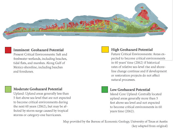
The future that likely awaits all this development is laid out in a color-coded map of geological hazards authored by three Texas coastal geologists for the city of Galveston. Red for imminent hazards, yellow for high hazards, the map projects what Galveston could look like in 2062. “I think a lot of people were really unhappy to see that geohazards map,” says John Anderson, a professor of oceanography at Rice University and one of the map’s authors. “It was a hot potato; actually, it was a live grenade.”
Since its release last March, the geohazards map has rattled Galveston. Ironically, it offers a best-case scenario, say the mapmakers. It ignores the effect storms can have, moving shorelines 50 feet overnight. The map also leaves out the matter of climate change, which is expected to lead to higher sea levels globally, perhaps dramatically so. Starting at around 3 feet of total rise, a level some climate experts consider inevitable, and possible within this century, significant portions of the island could slip under water. Galveston and other low-lying parts of the upper Texas coast will probably bear the brunt of climate change.
The magnitude of this slow-motion collision between man and nature is hard to grasp, and even harder for some to accept. “It’s sort of inconvenient,” says Jackie Cole, a former city councilmember who was instrumental in commissioning the geohazards map. “It’s a difficult thing to face. It’s like sitting down in a doctor’s office and finding out you have a terminal illness.” Cole stresses that she doesn’t believe the island is actually dying. People are resourceful and resilient. Galvestonians, especially, have learned to cope with disasters. But, she says, learning to live and deal with reality requires facing it first. “In all the stages of grief, the first stage is denial.”
Galveston breaks roughly into two camps-those who would fight Mother Nature and those who would bend to her will. Jerry Mohn, the owner of a chemical distribution company in Houston, belongs decisively to the former group, the “defenders.” And he has a name for the other side: “retreatists.” “Goodbye island,” he says, summing up the geohazards map with mock irony. Then he gets serious. “But this is what happens if we don’t do something to protect the island. And it’s going to cost a hell of a lot of money.”
Money that will likely come from taxpayers.
Mohn sometimes sports a T-shirt with a slogan that neatly sums up his quest-“Got Sand?” Sand is the lifeblood of the West End. It forms the beaches that attract residents, and it holds the ocean at bay. But sand is scarce-virtually none is being naturally deposited in the Galveston area-and the dune system that would protect the island from storm surges has been decimated by storms and development. Meanwhile, erosion has put dozens of homes on the wrong side of the vegetation line, the somewhat ambiguous demarcation separating public beach from private property. (Though enforcement has tapered off, the Texas Open Beaches Act requires that structures on the public beach be removed.) The solution, as Mohn sees it, is beach nourishment, a fancy term for dumping sand on beaches. “All we’re looking for is to have the erosion rates back to where Mother Nature intended it,” says Mohn.
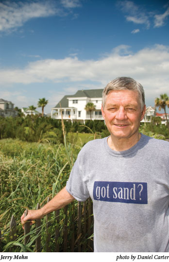
Mohn and fellow West End residents have created the West Galveston Island Property Owners Association, an umbrella group of more than 35 property associations that together represent 40 percent of the island’s tax base. The organization boasts corporate sponsors from the insurance, banking, real estate, and energy sectors.
Mohn, fit and full of energy, looks every bit the businessman retired to the seaside. He recognized the need for the property association in 1998, after Tropical Storm Francis put dozens of homes on the public beach overnight. Quickly the organization went to work, lobbying the city, county, and state. In 1999, it scored its first victory-the state Coastal Erosion and Planning Response Act, a biennial, $15 million fund divvied up among affected coastal areas for shoreline protection projects. The organization has also formed close ties with the Texas General Land Office, convincing the agency to soften its stance on homes sitting on public beaches.
With large-scale nourishment projects running $3 million a mile and state funds limited, Mohn is now trying to tap Congress. The American Shore and Beach Preservation Association, founded in 1926, is similar to Mohn’s group, but on the national stage. Mohn is the president of the Texas chapter, and in October he hosted the association’s annual conference in Galveston, an extravaganza of engineers, politicians, and salesmen selling anti-erosion products. During the conference, General Land Office Commissioner Jerry Patterson, standing at the end of the seawall, announced a $13.5 million nourishment project, funded in part with federal money, for three miles of beach beginning at the seawall. “[T]his project is a knockout punch,” Patterson said. “This will be the biggest effort to preserve the Texas coast since the Galveston Seawall, and it might get bigger.”
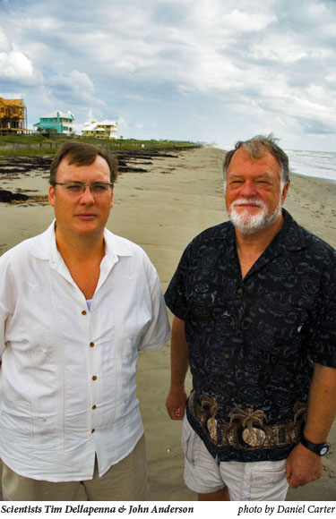
This sort of thinking irks geologist John Anderson. “I always tell people, if you see a [sand] truck going down [FM 3005 in Galveston] it’s probably full of your tax dollars and about to drop into the Gulf of Mexico.” Most beach nourishment projects, he says, are washed away within a year. The sand for the new GLO project is coming from a deposit that Anderson had recommended be saved for restoring beaches after a tropical storm. The real point of beach nourishment is to temporarily protect people’s investments. “We’re putting buckets of water on a forest fire here,” he says.
Still, the political urge to do something, anything, is overwhelming. Dianna Puccetti, a BOI (“Born on Island”) who represents the West End on the Galveston City Council, describes standing on the wrecked beach in the aftermath of Tropical Storm Frances in 1998. She and other local politicians were talking about the difficulty of spurring the state to fund anti-erosion projects. “I stood there, and I literally had tears in my eyes and said, if we can’t get people interested in it now, then we never can.” Despite victories like the $15 million from the Coastal Erosion and Planning Response Act, the property association needs quite a bit more cash. Mohn estimates that future shoreline projects will cost $100 million. The city employs a lobbyist in Washington, D.C., and two in Austin to fight for dollars.
Mohn, Puccetti, and other defenders acknowledge that the current options just buy time. “The permanent solution is coming in the form of a feasibility study,” promises Mohn. That would be a long-overdue shoreline erosion study of the upper Texas coast being conducted by the Army Corps of Engineers. No one knows when the study will be completed or what it will say, but Mohn expects the Corps will locate major sand sources offshore or prescribe some new technological fix. Millions have already been spent on successive waves of technology. The most pervasive device is probably the simplest: the Geotube, giant fiber socks filled with sand.
“They’ve been sold as something that protects the beach,” says Tim Dellapenna, an assistant professor of marine sciences at Texas A&M-Galveston and co-author of the geohazards map. “But they don’t do that. They protect upland private property.” In fact, unpublished fieldwork by one of Dellapenna’s students shows that the sand socks may actually enhance erosion. Meanwhile, they displace the dune system and encroach on habitat for sea turtles and shorebirds. In some places, the Geotubes render the beach impassable during high tides.
The notion that an engineering solution lies around the corner is in the DNA of islanders. “I’m not one of these people that feels that just because Mother Nature wants to do something, you need to let her do it,” said Craig Brown, a dentist-turned-developer and city planning commissioner, after Anderson had given a presentation on the island’s geological future. “Mankind has never been that way.”
The seawall stands as a monument to this belief. The “Great Storm” of 1900-still the deadliest natural disaster in U.S. history-nearly wiped out Galveston, razing almost every structure in the town and claiming more than 6,000 lives. Galveston could well have gone the way of other hurricane-ravaged Texas towns, such as Indianola, once an important port city near Port Lavaca, now an unincorporated community that lies partially under water. Yet within years of the 1900 storm, Galveston had rebuilt. Only an astounding engineering effort made this revival possible. Four years after the hurricane, the first 3.3-mile section of the concrete seawall had been completed. Still vulnerable to storm surges because of the city’s low elevation, engineers commenced raising 500 city blocks by as much as 11 feet.
The “retreatists” believe Galveston can’t engineer its way out of what’s coming. They propose using the geohazards map to direct development. Development would be banned in the red zones, and the yellow zones set aside as buffers. Chula Ross Sanchez, a planning commissioner and green architect, describes this idea as “pulling back from what you celebrate”-build on high ground and leave space between buildings and natural features like wetlands, bays, and beaches.
Finding acceptance for this new paradigm is hard. “The history of Galveston has been to adapt the island to people,” says Jackie Cole, the former councilwoman. “So it’s difficult to accept the end result or the concept of the geohazards map, because we have historically always been able to come up with some way to live here despite the fact that barrier islands are not places for people to live.”
Geologist John Anderson says he’s tired of explaining the map, and the science behind it, to city officials. “If they do not understand it, they should not be in public office,” he says sternly. An exchange he had with a city planning commissioner last August is telling. “We have to be responsible and measured in terms of the way we approach this so it doesn’t deter people from coming to visit our island,” Kelly Sullivan, a member of a prominent developer family, told Anderson after a presentation on the island’s geological future. “Believe me, the situation is bleak,” Anderson replied. “It’s not a good picture.”
When not in his office at Rice University in Houston, Anderson, an Alabama native with a touch of the salty seafarer about him, does research in the colder climes of Antarctica, studying melting ice sheets aboard a research vessel. That work puts him into close contact with the links between climate change and rising sea levels. “From a scientific standpoint, the evidence is strongly in favor of accelerated sea level rise,” Anderson says. Recent satellite data suggest that the rate of sea level rise has increased from 1.8 millimeters, about one-sixteenth of an inch, a year to 3 millimeters a year, about an eighth-inch, in the past 12 years. Nonetheless, there is significant uncertainty within the scientific community on how fast the oceans will rise. The U.N. Intergovernmental Panel on Climate Change, which shared the 2007 Nobel Peace Prize, gave a range of 7 to 23 inches by the end of this century. However, a number of scientific journals this year have challenged the IPCC figures as too conservative.
New Mexico-based environmental advocacy group Architecture 2030 modeled portions of Galveston Island at different increments of sea-level rise. At 1 meter-about 3 feet-more than half of Jamaica Beach, an incorporated community of 1,075 on the West End, is under water. The 740-acre, $2.6 million wetland restoration project at Galveston Island State Park is drowned by the bay. The airport runways will require amphibious planes. At 1.5 meters, Moody Gardens, a nature-themed tourist complex, practically becomes an island. The Strand is mostly flooded. At 2 meters, nearly the entire West End-two-thirds of the island-is submerged. Modeling using a different, cruder methodology conducted by the University of Arizona shows very little of Galveston left high or dry at 2 meters. None of this research was included in the geohazards map, and the defenders cling to scientific uncertainty to ward off concerns about rising sea levels. “Global warming, sea-level rise, whether it’s man-made or it’s the natural process we’re going through, that’s to be determined,” says Mohn.
To generate a sense of the powerful forces at work on Galveston Island, both economic and natural, geologist Tim Dellapenna gives a tour of the West End that starts with an internationally recognized erosion hot spot-the end of the seawall. Once, a beach extended 100 feet in front of the seawall. Black and white photographs on the wall of a nearby restaurant show old cars driving on the beach. Now the Gulf laps at the foot of the seawall. What little beach remains is trucked in, courtesy of the taxpayers, from accreting beaches on the far east end of the island.
Everything west of the seawall is the West End, where the island becomes lower, narrower, and more exposed. A patchwork of old and new subdivisions, working ranches and Indian burial grounds, second-homes and people who’ve never left, the West End is part of the city of Galveston and a world apart. As recently as the 1960s, you could drive onto the beach from the seawall and travel uninterrupted for 18 miles, all the way to the other end of the island. No more. The shoreline has moved landward 500 feet since the 1960s, according to Dellapenna.
Despite the high erosion rates, a new condo development is going up nearby. Randall Davis Co., a swanky Houston development outfit, has just broken ground on Diamond Beach, a pink-and-white resort. It will include a “Lazy River” water ride and a private beach. (Randall Davis Co. did not respond to several requests for comment.) Most of the project is relatively safe behind the seawall, but a small portion sticks out.
Elizabeth Beeton, a city planning commissioner, notes that when the issue of the advancing shoreline was raised during a permit hearing, the developer agreed to set part of the project farther from the beach. The commission approved the beach construction permit without requiring the change. “Here’s a developer saying, we’ll move back, and the planning commission goes ‘don’t bother, we’d rather you not,'” Beeton says.
Diamond Beach hasn’t stirred nearly as much controversy as The Preserve at West Beach, a huge project farther down the island that stretches from beach to bay. The master planner, Chicago-based Marquette Land Investments, has plans for 4,000 residential units, a golf course, a marina, five midrise condominium buildings, and a hotel with two 16-story towers. Despite the set-aside of a 361-acre nature preserve, Marquette’s plan to build on a tract of land with an intact island ecosystem of uplands, wetlands, and marshes has ignited intense criticism.
Dellapenna cruises through the 1,058-acre working ranch Marquette is going to turn into the Preserve. Cows wade in a bayou. Waterfowl float in a freshwater marsh. On the geohazards map, the company’s designated nature preserve is blotted in red, an area of imminent hazard because of its low elevation and sensitive habitat.
In June, not long after the geohazards map was released, Planning Commissioner Ross Sanchez took it upon herself to superimpose the Marquette plan onto the geohazards map. The projected shoreline in the year 2060 ran right through the lobby of the hotel. “I held [the superimposed map] up and said, this is why I’m voting against this. It makes no economic sense for the developer,” says Sanchez of the vote to permit the project. Marquette partner Darren Sloniger says the company has since pulled the towers out of the red zone and most of the yellow zone. The company will spend the next year looking at anti-erosion solutions, from a regional beach nourishment project to experimental technology, Sloniger says.
These concessions have done little to dampen opposition. One organization is calling for the entire development to be scrapped and replaced with a beach-to-bay preserve and ecumenical Cabeza de Vaca Spiritual Center. Sloniger has an explanation for the opposition. “When you look at our project, we’re laying in between some of the most affluent and well-organized subdivisions on the island; there’s kind of a not-in-my-backyard mentality.”
Jeff Sjostrom, president of the Galveston Economic Development Partnership, worries more about halting construction than the potential environmental consequences of moving forward on future developments. He talks about what a boon the expected $2.6 billion in investment will be. “To find the same level of investment, we have to go back to the building boom after the 1900 storm,” he says.
Sjostrom recalls that just a few years ago he would go see investors in Houston about building new homes in Galveston. “They said, are you crazy? What are you smoking?” Susceptible to hurricanes and considered an economic laggard, no one wanted to waste time on the island. Now builders come see him. That means the city can start thinking about what to do with its growing tax base-invest in schools, expand beach nourishment, work on conservation projects. But opponents threaten to spoil the good times. Sjostrom says they are “using the geohazards map to stop development.”
Ironically, the more successful developers are at building high-end residences in risky environmental areas on the West End, the stronger the constituency for costly bailouts in the event of storms or erosion.
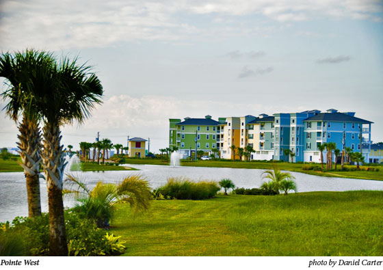
The penultimate stop on Dellapenna’s tour is on the far-western tip of the island, where Centex Corp.’s Pointe West is located. Now two years old, the 1,100-acre, $500 million master-planned resort features trendy villas, 3 miles of beaches, and a plum spot on one of the most dynamic and vulnerable spots on the island-San Luis Pass. “[Pointe West] will be run over by a hurricane someday and totally flattened, and if that doesn’t happen, there will be a shift in shoreline movement, and some of those places will be in danger of falling into the ocean,” says Jim Gibeaut, a research professor at Texas A&M-Corpus Christi and the lead author of the geohazard map. A glimpse into this future can be seen next door at San Luis Shores, an adjacent development that was never completed and is now a popular surf-fishing spot. Under way in the ’80s, the project went belly-up before any structures were built. Today the streets the developer put in run straight into the ocean. (Centex did not return requests for comment.)
Anderson says he thinks Centex bought a fair amount of time by setting homes back from the ocean a fair distance. He’s more perturbed that the developer built homes right up to the edge of the wetlands. As waters rise, wetlands can survive by migrating landward. However, hard structures such as the concrete bulkheads at Centex can block that movement. “Rates of bay erosion are even faster than beach erosion,” Anderson says. “If we continue to allow development up to the edge of wetlands, then 50 years from now, those wetlands won’t be around anymore.” Among their many benefits, coastal wetlands provide protection from storms. The U.S. Army Corps of Engineers estimate that every 2.7 miles of wetlands reduces a storm surge by one foot. In all, 35,000 acres of wetlands around Galveston Bay have already been lost since the 1950s, according to Bob Stokes, president of the Galveston Bay Foundation. On Galveston Island, estuarine marshes have shrunk 32 percent since the 1950s, from 5,505 acres to 3,753 acres, according to a University of Texas study. Most of that loss can be attributed to subsidence, but Stokes says the biggest threat is now sea-level rise combined with unchecked development.
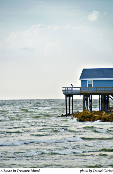
The final stop on Dellapenna’s tour requires leaving Galveston. Past the toll bridge that spans San Luis Pass is Folletts Island. Here at the eastern extremity of this low-lying, sparsely inhabited spit of land lies the dubiously named Treasure Island community, where at least one home has literally gone out to sea and is accessible only by a long pier. The place is called “Noah’s Ark,” and rents for $2,600 a week. Next door another home-currently being remodeled-is bounded on three sides by concrete bulwarks, like some medieval garrison holding off the invading sea. Spray splashes over the wall. A no-trespassing sign is subtitled “Free Go To Jail Pass.” “This is what Galveston Island could be like in 100 years,” says Dellapenna. “These are the sort of erosion rates we would expect, and this is the sort of protection we would likely see.”
The beaches are gone. All that remains is evidence of failed engineering schemes-Geotubes, granite riprap, and concrete revetments. “This is a monument to something, that’s for sure,” says Dellapenna. He pauses. “Hubris, I guess.”
You May Also Like
70 Years of Skewering
The “magic dust” of adding funny drawings to words has been an important part of the Texas Observer.
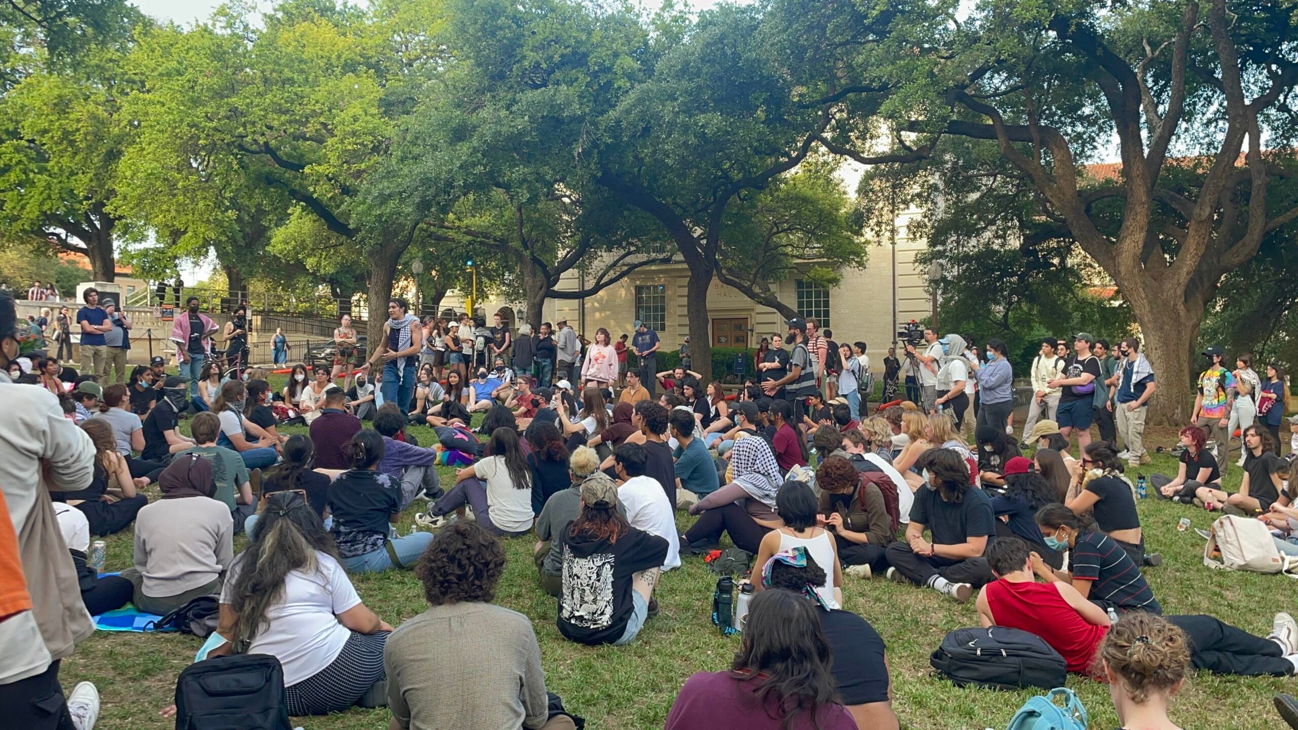
Did Texas Police Violate First Amendment Rights of Pro-Palestine Protesters?
A UT professor and expert on freedom of expression weighs in on the controversial arrests of 57 individuals, including a journalist, at a campus demonstration.

Texas Exotic Hunts Are Dangerously Unregulated
Some hunting ranches in Texas routinely offer hunts of endangered or threatened exotic species. This should not be allowed.