Records Show Where Trump Plans to Build Texas Border Wall
The 15 segments of wall would tear through three wildlife areas in the Rio Grande Valley and put more homes and other structures in jeopardy than previously known, the documents show.
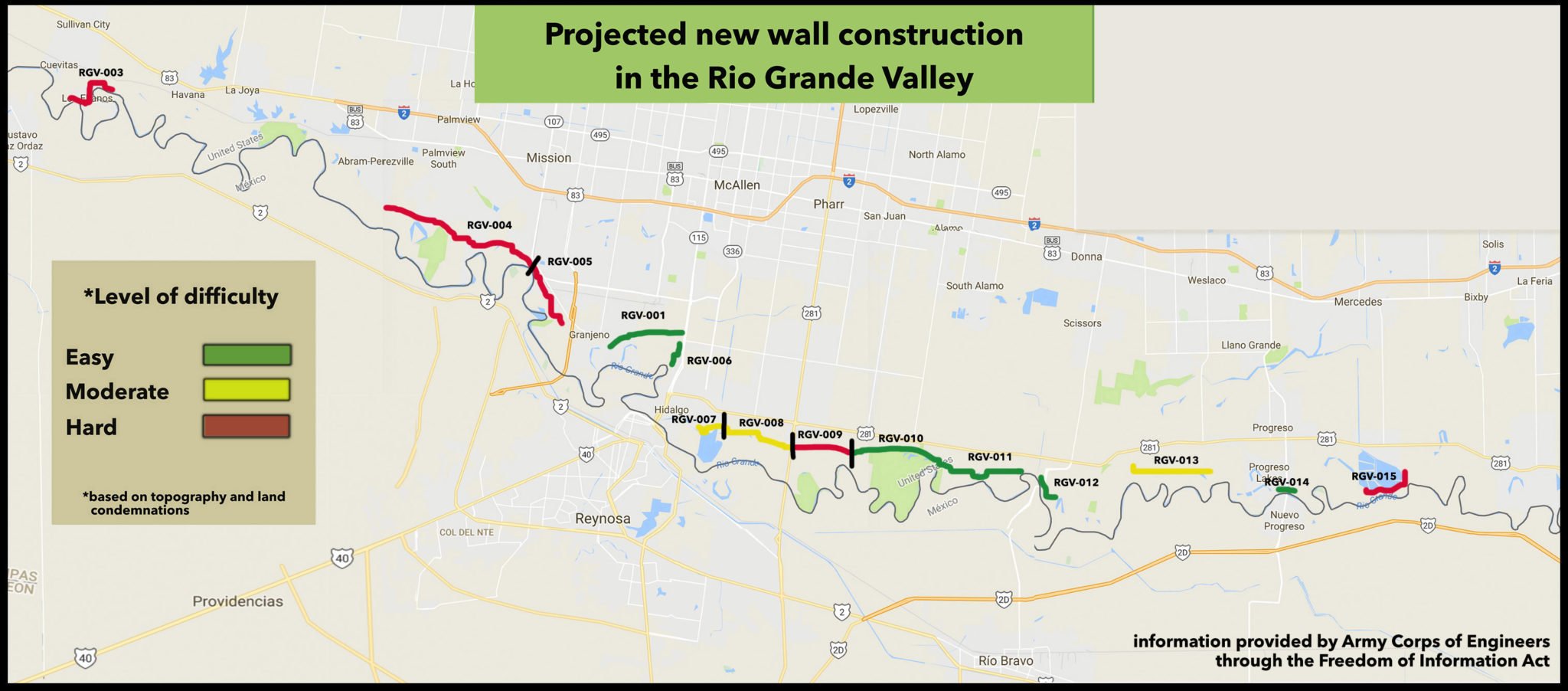
Documents obtained by the Observer offer new insights into the Trump administration’s plans for a border wall in portions of the Rio Grande Valley. A map produced in May by the U.S. Army Corps of Engineers shows where the administration expects to build 33 miles of wall in 15 different segments, including portions that would tear through three wildlife areas. The documents also reveal a rating system the administration is using to rank the difficulty of building each segment, based on the topography and the legal difficulty of taking over the land.
“Nice RV park, many retirees live there permanently,” reads the entry for a nearly 2-mile segment that would cut off the Chimney Park RV Resort, the historic La Lomita Chapel and the Riverside Club, a popular hangout for winter Texans. “Western half of segment will impacts [sic] upward of 100 homeowners.” The Army Corps rates building the section as “most challenging.”
According to the documents, the wall would bisect the Bentsen-Rio Grande Valley State Park, a 797-acre preserve that’s one of the top birding destinations in North America. Walls would also run through the neighboring National Butterfly Center, a private nature sanctuary that recently announced it would sue the government to stop construction, as well as the Santa Ana National Wildlife Refuge. The Army Corps of Engineers rates the Santa Ana refuge as an “easy” location, because the land is already owned by the federal government.
In early July, the Observer revealed the government’s plan to build a 2.9-mile levee wall through Santa Ana, one of the nation’s oldest protected wildlife habitats. Located about 10 miles southeast of McAllen, the refuge is home to at least 400 bird species and 450 species of plants, and it hosts both the rare Texas Sabal Palm and the endangered ocelot.
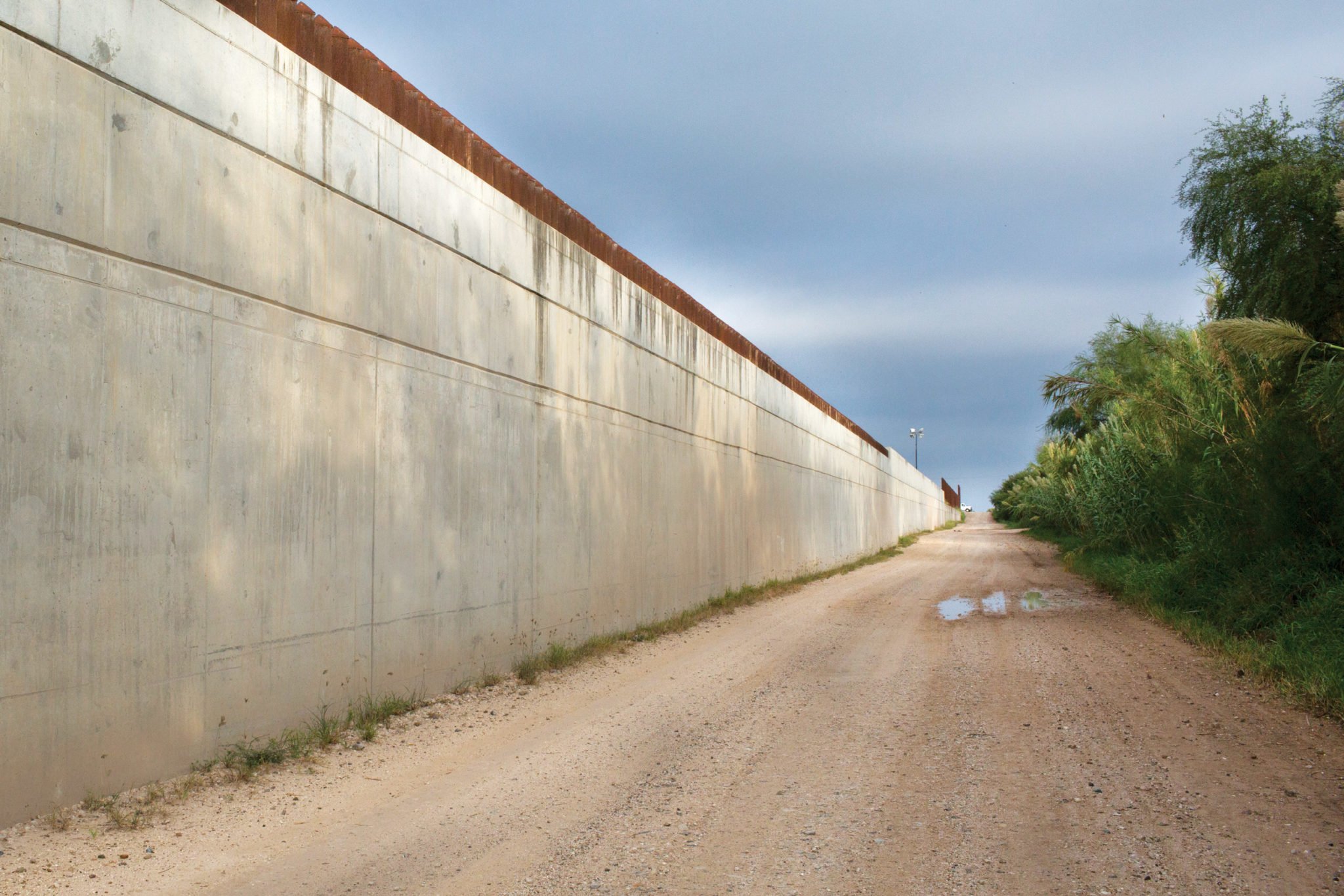
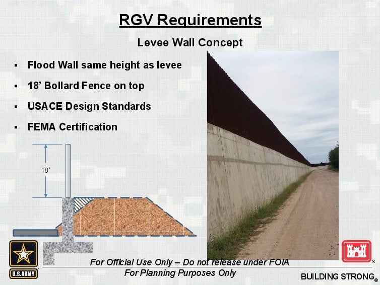
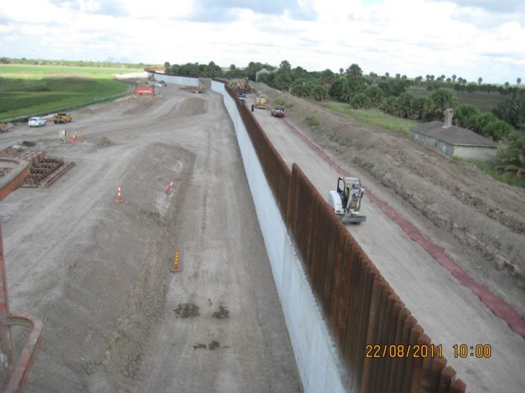
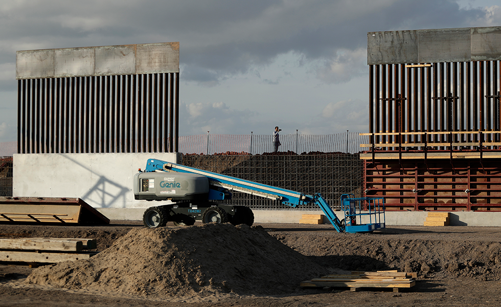
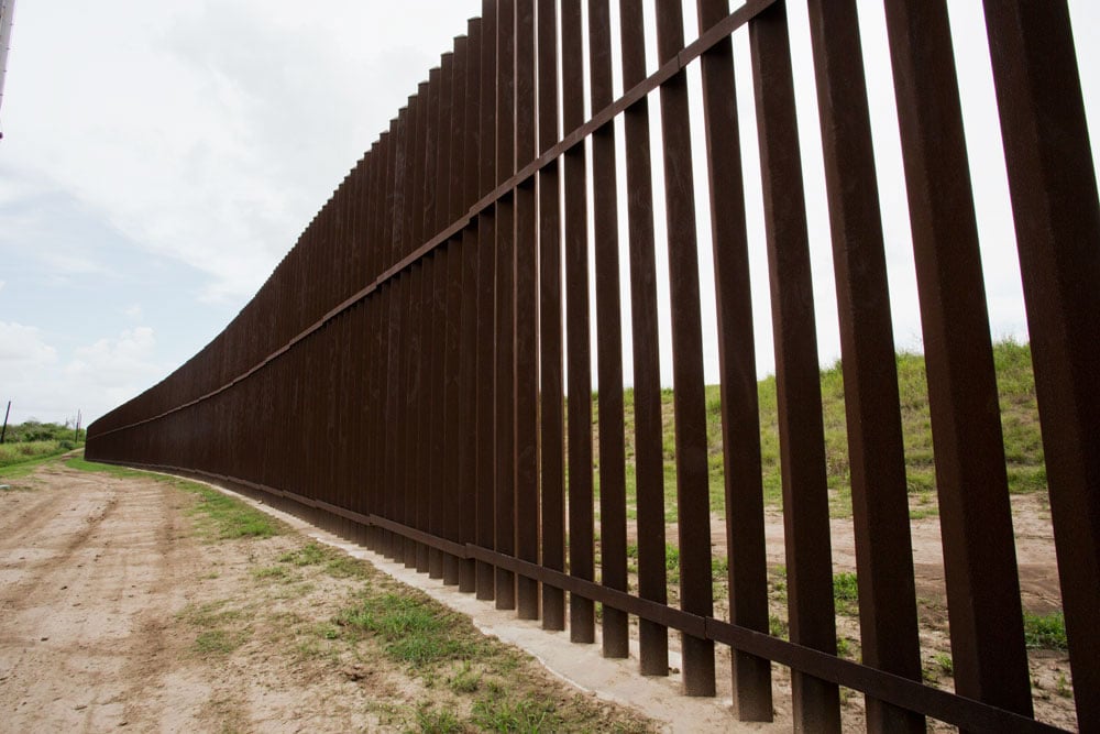
The documents label the wall planned for Santa Ana as a “pilot project.” The levee wall there will consist of a concrete base, which will replace the existing earthen levee, topped by an 18-foot steel bollard fence. The Santa Ana segment is projected to cost $45 million — approximately $15 million per mile — and is slated to be completed by July 2019, according to Army Corps of Engineers records.
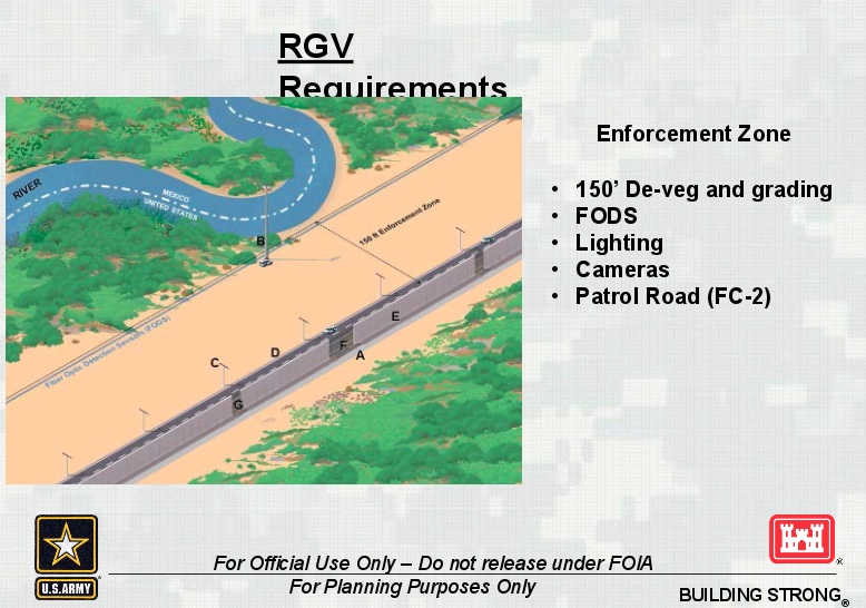
The government also has more in mind for Santa Ana than just a wall. An Army Corps PowerPoint presentation shows plans for a cleared 150-foot “enforcement zone” that would run south of the levee wall. The enforcement zone would include an all-weather road bordered by underground fiber-optic motion sensors.
Emails between government engineers and employees from Michael Baker International, the construction firm working on the project, detail the installation of 120-foot-tall video surveillance towers and lights to illuminate the enforcement zone.
Donate now to support independent, nonprofit journalism.“With this type of construction it would be difficult for Santa Ana to stay open,” said Scott Nicol, co-chair of the Sierra Club’s borderlands team. Nicols requested the documents under the Freedom of Information Act and shared them with the Observer. “The 150-foot cleared area [for the enforcement zone] is bigger than the 60-foot wide strips of land they condemned for the border walls 10 years ago.”
A 150-foot enforcement zone is also being considered for other areas. The zone’s footprint appears to put homes and other structures in jeopardy. For a segment near Pharr, the Army Corps of Engineers’ analysis states “Many homes within 150’ … Church and cemetery directly impacted by enforcement zone.”
Records also show that the wall is behind schedule. The government planned to begin construction by breaking ground at Santa Ana as early as October 2017. However, other schedules drafted by the Army Corps of Engineers indicate that work at the refuge could begin as late as next summer.
“With this type of construction it would be difficult for Santa Ana to stay open.”
In May, Congress approved $341 million for repairs or replacement of existing border walls — a fraction of the $1 billion President Donald Trump requested to build his “big, beautiful” wall. For the Rio Grande Valley, $49 million was earmarked to install 35 gates in the gaps between existing wall segments. If Border Patrol decides to keep the gates closed, access could be restricted to the Sabal Palm Audubon Sanctuary, the homes of several landowners who live south of the wall, acres of farmland and the Nature Conservancy’s Lennox Foundation Southmost Preserve in Brownsville.
Nationwide, at least 654 miles of barriers already exist along the nearly 2,000-mile border, but they are primarily in California and Arizona, where most land is federally owned. Attempts to build the wall on private land in Texas a decade ago touched off protests and court battles between landowners and the U.S. government over land condemnations. Several legal cases are still pending.
This time, battles over the border wall could be even more contentious as the Trump administration targets an increasing number of landowners and protected wildlife habitats.
U.S. Customs and Border Protection declined to comment for this story.
Congressman Filemon Vela, a Brownsville Democrat whose district includes the Santa Ana National Wildlife Refuge, has been a vocal opponent of Trump’s wall, even making international headlines when he told the president he could “shove it up your ass.” Vela was cautiously optimistic that Democrats would block funding again for Trump’s wall in the 2018 budget.
“Trump will only get his border wall funding if Democratic leadership capitulates to his demands,” Vela said. “We can only hope that Senator Schumer and Leader Pelosi will draw a line in the sand and oppose money for even an inch of border wall construction.”
You May Also Like
2020: The Year Trump’s Wall Rises or Falls
The president may be incompetent and behind schedule, but he’s done damage already. And a lot more could be on the way.
Starr County Proposes Alternative Border Wall Plan
New maps obtained by the Observer represent a local plan developed as part of a Congressionally mandated consultation process.