New Border Walls Designed to Flood Texas Towns
With flood waters from the swollen Rio Grande inundating the community, a mandatory evacuation order was issued for the small border town of Los Ebanos on July 12, 2010. Hurricane Alex, with a tropical depression close on its heels, had poured rain onto the mountains around Monterrey. Water rushed into the Rio Grande, flooding Roma, Rio Grande City, Los Ebanos, and other riverside communities.
Those towns were still underwater eight days later, when Customs and Border Protection (CBP)met with the U.S. section of the International Boundary and Water Commission (USIBWC)and the State Department in Washington D.C. For three years CBP had been trying to convince the USIBWC to allow them to build border walls in the Rio Grande flood plain, but USIBWC had repeatedly refused, citing unacceptable risks to lives and property on both sides of the river.
CBP opened their presentation by stating that because the Mexican half of IBWC continued to oppose walls “we need [US]IBWC and Department of State’s support for an unilateral decision to proceed with the fence construction.”
The International Boundary Water Commission is a bi-national organization charged with reaching consensus on actions that one country might take that would impact the other. By asking USIBWC to allow unilateral action in the face of Mexico’s objections CBP was asking them to violate the treaty upon which their agency is founded.
CBP’s presentation made no mention of the flood waters that were at that moment ravaging Texas border communities, submerging the sites of the proposed walls.
Mexico has good reason to fear the harm that border walls could inflict. In July of 2008 seasonal rains swept through the Sonoran desert, inundating the sister cities of Nogales, Arizona and Nogales, Sonora. The border wall that separated them acted as a dam. Water reached the tops of doorframes on the Mexican side, but was only ankle deep north of the wall. In Mexico two people drowned.
The same storm passed over Organ Pipe Cactus National Monument, where border walls became clogged with debris, causing them to act as dams. Water in usually dry washes reached depths of up to six feet and traveled along the wall until they reached the Lukeville, Arizona port of entry, causing millions of dollars of damage.
After the 2008 floods Baker Engineering was hired to examine the walls from El Paso to San Diego, and make recommendations for avoiding future flooding. The resulting report documented “debris build-up which sometimes reached a height of 6 feet,” and concluded that because of this, “fencing obstructs drainage flow every time a wash is crossed.”
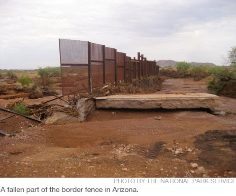
At Baker’s recommendation $24 million was spent installing flood gates in the border wall, but when another seasonal rainstorm washed over Organ Pipe Cactus National Monument last August walls once again clogged with debris and acted as dams. This time the force of the water tore down a forty-foot wide section of the border wall.
The border walls that CBP wants to build in the floodplain adjacent to Roma, Rio Grande City, and Los Ebanos would look a lot like those that are standing, and sometimes falling, in Arizona.
According to documents obtained by the Sierra Club through a Freedom of Information Act request, in 2009 CBP hatched a plan to get approval for the walls that IBWC had rejected. They would not move them out of the floodplain; instead “the new strategy involves developing a new floodplain model.” In contrast to a previous IBWC model that “predicted noteworthy floodplain impacts from the fence […] this model will demonstrate the impacts of the proposed fence will be minimal.”
Eight months after CBP forecast its results, the new floodplain model was delivered by Baker Engineering claiming, not surprisingly, that border walls would have a “minimal effect on the Rio Grande floodplain.”
In an attempt to allay Mexico’s fears that walls in the United States would deflect water into their cities a key change was made to the walls’ design. The walls were now intended to “split” the flooding river, with part of the flow channeled along the northern, U.S. side. To reduce the volume of water deflected into Mexican cities more floodwater would pour into Roma, Rio Grande City, and Los Ebanos.
Each border wall section would begin close to the river, but as the river twisted and bent the wall and river would grow farther apart. Floodwaters split off at a wall’s western end would therefore flow into homes and farms set back from the river that without the wall might have been spared.
To ensure that waters were sent into the United States rather than Mexico, the wall next to Roma now included a 100 foot wide opening designed to take in flood waters, and Rio Grande City’s would have a 275 foot wide opening.
Los Ebanos, which sits atop a deep bend in the river, would likely suffer the most from splitting. Where the wall and the river would meet the river runs south, away from homes and the local school, but the wall and its channeled flood water would head due east, directly towards them. On the other side of town the wall would make a ninety degree turn, heading north and preventing the split floodwaters from flowing back into the Rio Grande.
Customs and Border Protection tried to use the new model to convince the USIBWC to permit these walls, but on January 21, 2010, USIBWC Commissioner Edward Drusina again rejected them, citing the likelihood of “substantial increases in water surface elevations and deflections of flow at several points of all three projects.”
Throughout 2010 CBP repeatedly asked USIBWC to ignore their treaty obligations and approve unilateral action. Acting Chief David Aguilar, for example, asked that“ USIBWC and Department of State reconsider your position and approve a unilateral decision .” A few months later, with Los Ebanos under an evacuation order, the meeting with IBWC and the State Department was held to again push for unilateral action.
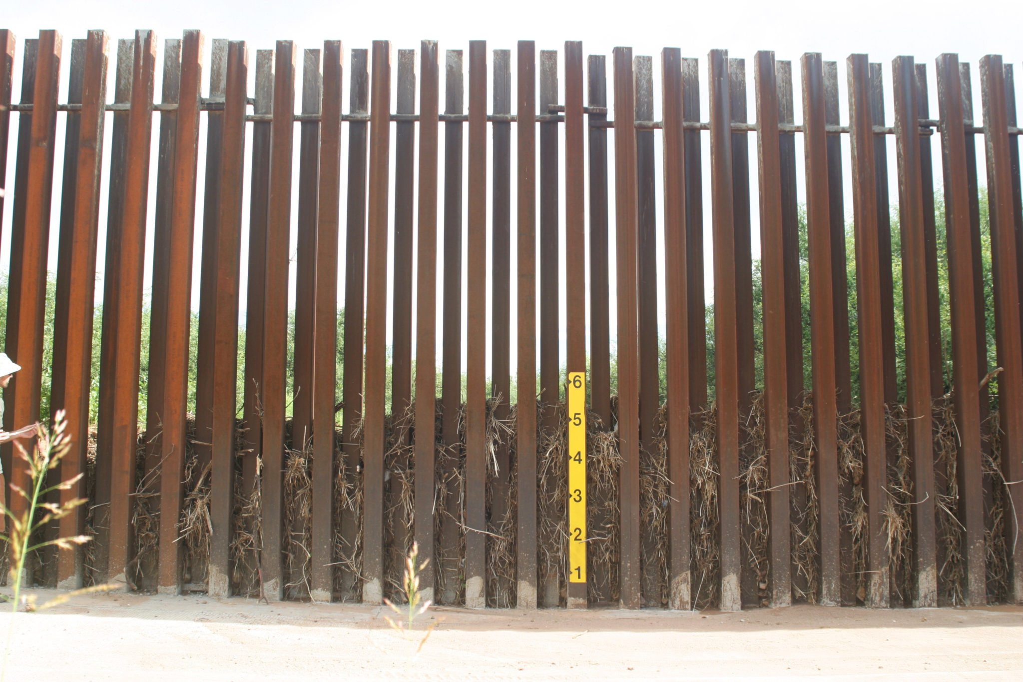
Baker Engineering was hired to develop yet another flood plain model in 2011 to bolster CBP’s argument that walls would be harmless The new model envisioned a line of eighteen foot tall steel posts spaced four inches apart, identical to the border walls that stand north of the levees near Brownsville. Baker claimed that because of the spaces between the posts only 10-25% of the floodwater would be blocked, so there would be no significant deflection of water into Mexico or additional flooding in the United States.
The report provided no evidence to support this estimate, and overlooked the likelihood of debris turning the otherwise permeable structure into a dam, as had happened in Arizona. This is the same contractor who, just two years earlier, had found that every time this type of wall crossed a wash in the desert debris built up to depths of up to six feet.
There is no precedent for a debris-free flood. An incident report from the 2010 flood stated that “The actual river contains and is carrying [a] lot of natural debris consisting of trees, branches, reeds, and other man-made objects.”
But something happened at the US half of the International Boundary and Water Commission.
In September of 2011, and again in November, John Merino, the US section’s Principal Engineer, wrote to his Mexican counterpart to say that US IBWC had read the Baker report and “concluded that the project will not cause significant deflection or obstruction of the normal or flood flows of the Rio Grande.” Mr. Merino recommended approval of the border walls.
Mexico did not buy into the US section’s reversal. In December the Mexican section of the IBWC responded, “…the location, alignment and design of the proposed fence represent a clear obstruction of the Rio Grande hydraulic area, since in the towns of Rio Grande City and Roma, TX, the fence would occupy nearly all of the hydraulic area on the U.S. side, causing the deflection of flows towards the Mexican side. If you consider that, given the design characteristics, the fence obstructs 60-70% of the hydraulic area in a direction perpendicular to the flow, and if you add to that the effect of the current retaining trash and debris, the significant length that is located in the floodplain, and the position of the fence relative to the direction of flow, the fence constitutes a serious obstruction and deflection of the Rio Grande flows towards Mexico. […] We reiterate our opposition to the construction of the proposed fence in the Rio Grande floodplain given the impacts stated above.”
Two months later Mr. Merino responded, telling Mexico that the US section of the IBWC would permit construction of the same border walls in the floodplain that it had rejected since 2007. Customs and Border Protection was then given the green light to take unilateral action and build walls in the flood plain.
The US International Boundary and Water Commission’s reversal is clearly a capitulation, and their lack of spine is not just a treaty violation for diplomats to fret over; property will be damaged and people may drown on both sides of the river if these walls are built.
Of course it is Customs and Border Protection that will erect these walls, and who bears ultimate responsibility for their impacts.
When CBP argued for unilateral action in 2010, they claimed that, “The construction of O-1, O-2 and O-3 [Roma, Rio Grande City, and Los Ebanos] is critical to our Nation’s security.” But two years earlier CBP stated, “The Rio Grande Valley Sector Chief has determined that operational areas that contain the PF225 fence segments such as O-1 to O-2, O-12 through O-14, and O-17 through O-21 to be in “effectively controlled” level at the current time.”
They needed these walls, they said, because undocumented traffic through these areas might increase in the future and overwhelm agents. But it didn’t. The number of apprehensions in the Rio Grande Valley dropped by 20% from 2008 to 2009, and since that time the number of crossers has continued to go down, while the number of Border Patrol agents has gone up.
These three isolated border wall sections will have no impact whatsoever on immigration, smuggling, or national security. But if they are standing when the next big hurricane roars up the Rio Grande they will send flood water into homes, businesses, and farms on both sides of the river, and people could die as a result.
Customs and Border Protection has become so fixated on building border walls that they are prepared to violate the treaty that established the border, and sacrifice the lives and property of those of us who live beside it.
Scott Nicol is co-Chair of the Sierra Club’s Borderlands Team. He lives in McAllen, a few miles north of the border wall.
You May Also Like
Did Texas Police Violate First Amendment Rights of Pro-Palestine Protesters?
A UT professor and expert on freedom of expression weighs in on the controversial arrests of 57 individuals, including a journalist, at a campus demonstration.